Showing 131 items matching fire maps
-
 Warrnambool and District Historical Society Inc.
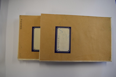
Map - Fire Maps, Region 5 Fire Control Map, 1963
... Fire Maps...Region 5 Fire Control Map ...Fire Maps..., are fire maps of portion of south west Victoria (Region 5... Street (south of Merri St) Warrnambool great-ocean-road Fire Maps ...Two fire maps of south west Victoria.1 This is a rectangular piece of linen folded several times to form a packet with the front part covered with a brown card. The cover has a blue and white label. The map has a white base with red and green markings and red and black printing .2 As .1 abovenon-fictionTwo fire maps of south west Victoriafire maps, warrnambool history -
 Clunes Museum
Map, 1962
... .1 &.2 MAP OF BALLARAT SHIRE GROUP RURAL FIRE BRIGADES FIRE... &.2 MAP OF BALLARAT SHIRE GROUP RURAL FIRE BRIGADES FIRE ....1 &.2 MAP OF BALLARAT SHIRE GROUP RURAL FIRE BRIGADES FIRE CONTROL MAP. COMPILED BY C. H. FENTON. (2 COPIES) DETAILING SEALED ROADS, STATE FORESTS, PINE PLANTATIONS, FOREST AREAS, RAILWAYS, BOUNDARIES, TOWNSHIP AREAS CEMETERIES, CREEKS, SWAMPS AND HOUSES.local history, document, maps, fire brigade -
 Victorian Aboriginal Corporation for Languages
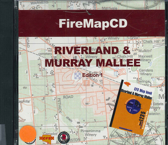
CD-ROM, Country Fire Services South Australia, FireMapCD Riverland &? Murray Mallee, 2001
... South East map book at Padthaway. CD-ROM fire protection ...The area covered by this map is the same as the CFS Riverland & Murray Mallee Map Book. The area covered adjoins the Mount Lofty Ranges map book on the eastern boundary at Murray Bridge, north to Morgan and east to Renmark and the State Border. It extends southwards to join the northern boundary of the Lower South East map book at Padthaway.CD-ROMfire protection, victorian maps -
 Victorian Aboriginal Corporation for Languages
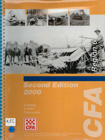
Map, Country Fire Authority, Region 6 rural directory, 2000
... regional maps fire protection Country Fire Authority ...maps, b&w photographscolac, lismore, cressy, lake corangamite, camperdown, terang, cobden, peterborough, port campbell, apollo bay, forrest, victorian regional maps, fire protection -
 Kew Historical Society Inc
Map, Department of Lands & Survey, Map of Melbourne & Suburbs, 1899
... Map accompanying report on fire protection of Melbourne... Map of Melbourne & Suburbs Map accompanying report on fire ...The Melbourne & Metropolitan Board of Works was established in 1891 to oversee the introduction of a sewerage and water reticulation system in Melbourne and its suburbs. This complementary map was produced by the Department of Crown Lands & Survey [Victoria] in the same decade showing the distribution of water in Melbourne for use by fire brigades. While by 1910, there were 123,227 connections to Melbourne's water supply system, it is unclear in this 1899 map whether water was supplied to all built structures in the defined areas or only to fire hydrants and stand pipes, as we know that the first connection of a building to the sewerage system in Kew only occurred in 1904.Map accompanying report on fire protection of Melbourne showing those areas supplied with water in colour.water reticulation -- melbourne (vic.), department of lands & survey -- historic maps, fire brigades -- melbourne (vic.), cartography -
Glenelg Shire Council Cultural Collection
Map - Fold-out fire control map - Region 4 Victoria, n.d
... Fold-out fire control map - Region 4 Victoria...Fold-out fire control map for Region 4 - Victoria Northern... Cliff Street Portland great-ocean-road Fold-out fire control map ...Fold-out fire control map for Region 4 - Victoria Northern sheet, includes numerical and alphabetical index. -
Stawell Historical Society Inc
Map - Laminated Map, Country Fire Authority, Mt Lubra and Deep Lead Fires Estimated Perimeters 2005 - 2006, 17/3/2006
... Coloured Laminated Map of Fire Spread...Laminated Map Map Mt Lubra and Deep Lead Fires Estimated ...Huge Fire Event in Grampians started by lightning strike at Mt Lubra on 19/1/2026 during a prolonged dry period. Stawell Deep Lead fire 31/12/2005 just three weeks earlier. Two people died on Moyston / Pomonal Road. Huge stork and feed loss.Coloured Laminated Map of Fire SpreadCFA GIS Services Community Safety -
 Bendigo Historical Society Inc.
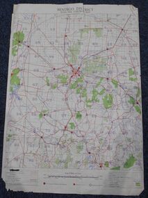
Map - Bush Fire Control Map Bendigo District
... Bush Fire Control Map Bendigo District...A Bush Fire Control map is a valuable tool used...A Bush Fire Control map is a valuable tool used ...A Bush Fire Control map is a valuable tool used by emergency services and communities to respond to respond to bushfires.Cream coloured parchment map showing roads, railway lines, telephone lines, rivers, creeks and water courses. Also marked are houses, Post Offices, Police stations, bush fire brigades, water channels, swamps, marshes, dense, medium and scattered timber, aqueducts and reservoirs. Villages, districts and Towns are clearly marked. Printed in red, green, black and blue. Very clear and easy to read. Undated.bush fires, bendigo area map -
 Melbourne Tram Museum
Pamphlet, Metlink, "New Year's Eve 2010 - public transport staff guide", 2009/2010
... , fire works map...., fire works map. Demonstrates an information document produced ...Pamphlet issued by Metlink as a guide to staff working on New Year's public transport 2010. Provides a guide to transport services, free travel, all night services, getting home, fire works map.Demonstrates an information document produced by Metlink for staff.Pamplet - 6 fold DL printed on gloss paper.trams, tramways, melbourne, metlink, new years eve, public transport -
Southern Sherbrooke Historical Society Inc.
Information folder - Fires 2003, 2003
... -3 Fire Overview maps, dated 24 January, 27 January (2 copies...-east Victoria by Andrew Aubert -3 Fire Overview maps, dated 24 ...Folder containing information pertaining to the 2003 Victorian, NSW & ACT bushfires. Contents: -3 photos of Omeo after the fires, by Dulcie Strahan -DSE/DPI Fire Update report dated 21st February -2 photos of fires in North-east Victoria by Andrew Aubert -3 Fire Overview maps, dated 24 January, 27 January (2 copies) and 16 February -leaflet, "Upper Murray Fires", community update, dated 12 January -copy of fire overview map, dated 16 February, with annotations -weather page, Border Mail, 8 Januarybushfires -
 Forests Commission Retired Personnel Association (FCRPA)
Drop Chute
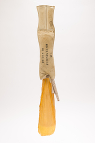
... missions and to map fire boundaries. The information was often... missions and to map fire boundaries. The information was often ...From the early 1960s, the Forests Commission had pre-season arrangements in place with local aeroclubs and pilots across regional Victoria. Air observers from FCV districts routinely flew during the summer months in small, fixed-wing aircraft on fire spotting missions and to map fire boundaries. The information was often needed quickly by crews on the ground or in the control centre and these small chutes were used to drop messages and maps from the reconnaissance aircraft on a low pass above a cleared area like a football field. About 3-foot long when fully extended, they had a small pouch secured with a press stud for the map or package. The chutes were made from tough canvas with a small, weighted sandbag at one end and a long yellow streamer tail on the other to help direct its fall and locating it on the ground. Drop chutes were still in common use in the 1990s, but the increased availability of helicopters combined with improved digital data transfer made drop chutes redundant. Simple, but now redundant technologyAerial drop chute"Return to Forests Comm Vic" stenciled on sidebushfire -
 Flagstaff Hill Maritime Museum and Village
Document - Map, Department of Lands & Survey, Victoria / Panmure, 1942
... transmission lines, and fire stations. The map has margin notes... transmission lines, and fire stations. The map has margin notes ...This Emergency Edition of the map of Panmure, Victoria, is part of the W.R. Angus Collection. It was printed in 1942 during World War II. It is one of two maps donated to Flagstaff Hill Maritime Village by the family of Doctor William Roy Angus, who served as Surgeon Captain in the Australian Defence Department. The map was compiled for the Dept. of Army by the Dept. of Lands and Survey in Melbourne, prepared by the Australian Section of the Imperial General Staff, which was a British Government body created in 1907 to co-ordinate the defence of Britain and its Empire. It was printed by A.H.Q. Cartographic Company, Survey Corps, which was formed in 1941. The Corp changed its name to L.H.Q. Cartographic Company of Bendigo. In 1947 the name reverted back to the A.H.Q. Cartographic Company until 1955 when it became the A.H.Q. Survey Regiment. The W.R. Angus Collection includes historical medical equipment, surgical instruments and material once belonging to Dr Edward Ryan and Dr Thomas Francis Ryan, (both of Nhill, Victoria) as well as Dr Angus’ own belongings. The Collection’s history spans the medical practices of the two Doctors Ryan, from 1885-1926 plus that of Dr Angus who began practice in 1924. Dr. Angus served with the Australian Department of Defence as a Surgeon Captain during the Second World Was from 1942 to 1945. He served in Ballarat, Victoria, and in Bonegilla, N.S.W. until he suffering from a heart attack just before the war ended. ABOUT THE “W.R.ANGUS COLLECTION” - Doctor William Roy Angus M.B., B.S., Adel., 1923, F.R.C.S. Edin.,1928, was generally known as Dr Roy Angus. His working life included a position as a doctor with the Flying Doctor Service in Australia’s rural and remote areas. After many varied experiences Dr Angus and his family moved to Warrnambool in 1939 where he purchased “Birchwood,” the 1852 home and medical practice of Dr John Hunter Henderson. He was appointed on a part-time basis as Port Medical Officer in Warrnambool and held this position until the 1940’s when the government no longer required the service of a Port Medical Officer. Dr Angus was a surgeon at the Warrnambool Base Hospital 1939-1942. After further studies he commenced practice as an ophthalmologist in Warrnambool, pioneering in artificial eye improvements. He was Honorary Consultant Ophthalmologist to Warrnambool Base Hospital for 31 years and made monthly visits to Portland to perform eye surgery. Dr Angus and his wife Gladys were very involved in Warrnambool’s community with a strong interest in civic affairs. They were both involved in the creation of Flagstaff Hill Maritime Village, including the layout of the gardens. After his death on 28th March 1970 his family requested his practitioner’s plate, medical instruments and some personal belongings be displayed in the Port Medical Office surgery at Flagstaff Hill Maritime Village, and be called the “W. R. Angus Collection”. This Emergency Edition of the Map of Panmure is significant as an example of the documents prepared for the defence of Australia in World War 2. The Map is also significant for its connection between the Australian Army and the involvement of Dr WR Angus as a Surgeon in the Medical Services during World War II. The W.R. Angus Collection is significant for still being located at the site it is connected with, Doctor Angus being the last Port Medical Officer in Warrnambool. The collection of medical instruments and other equipment is culturally significant, being an historical example of medicine, administration, household equipment and clothing from late 19th to mid-20th century. Dr Angus assisted Dr Tom Ryan, a pioneer in the use of X-rays and in ocular surgery. The collection includes Dr Angus’s Army objects and is significant as an example of items issued to Doctors and Surgeons in the Medical Services of the Australian Army in World War IIMilitary map of Panmure, Victoria, Australia; part of the W.R. Angus Collection. Rectangular coloured map on cream paper for the Australian Army. Details include sea, waterways and land, contour lines, grid lines, names of districts, towns and roads, bridges, swamps, rail lines, cuttings, tracks, buildings (including blacksmiths), pumps, lighthouses, telegraph, telephones and electric transmission lines, and fire stations. The map has margin notes that include distances in miles to nearby towns. The map was compiled for the Dept. of Army by the Dept. of Lands and Survey in Melbourne, prepared by the Australian Section, Imperial General Staff and printed by A.H.Q. Cartographic Company, Melbourne in 1942. Crown Copyright Reserved. Inscriptions in red print state that it is and Emergency Edition and an Official document. An oval purple stamp includes the price.Printed in black; 'Victoria / Panmure", "No. 930 / Zone 6" Printed in red; “EMERGENCY EDITION”, “THIS MAP IS AN OFFICIAL DOCUMENT. IF FOUND, IT MUST BE HANDED / IN TO THE NEAREST MILITARY HEADQUARTERS OR POLICE STATION” Stamped: within concentric ovals (“- - - FOR SALE / PRICE 2/- / - - - - - OF THE ARMY”)flagstaff hill, warrnambool, flagstaff hill maritime museum, maritime museum, shipwreck coast, flagstaff hill maritime village, great ocean road, dr w r angus, dr ryan, warrnambool base hospital, flying doctor, surgeon captain, australian department of defence, royal australian army, world war 2, map panmure 1942, roy angus, port medical officer, nhill base hospital, military map, emergency map, military service australian army, department of army, department of lands and survey, a.h.q. cartographic company melbourne, panmure 1942, australian section, imperial general staff -
 Flagstaff Hill Maritime Museum and Village
Document - Map, Department of Lands & Survey, Victoria / Port Campbell, 1942
... transmission lines, and fire stations. The map has margin notes... transmission lines, and fire stations. The map has margin notes ...This Emergency Edition of the map of Port Campbell, Victoria, is part of the W.R. Angus Collection. It was printed in 1942 during World War II. It is one of two maps donated to Flagstaff Hill Maritime Village by the family of Doctor William Roy Angus, who served as Surgeon Captain in the Australian Defence Department. The map was compiled for the Dept. of Army by the Dept. of Lands and Survey in Melbourne, prepared by the Australian Section of the Imperial General Staff, which was a British Government body created in 1907 to co-ordinate the defence of Britain and its Empire. It was printed by A.H.Q. Cartographic Company, Survey Corps, which was formed in 1941. The Corp changed its name to L.H.Q. Cartographic Company of Bendigo. In 1947 the name reverted back to the A.H.Q. Cartographic Company until 1955 when it became the A.H.Q. Survey Regiment. The W.R. Angus Collection includes historical medical equipment, surgical instruments and material once belonging to Dr Edward Ryan and Dr Thomas Francis Ryan, (both of Nhill, Victoria) as well as Dr Angus’ own belongings. The Collection’s history spans the medical practices of the two Doctors Ryan, from 1885-1926 plus that of Dr Angus who began practice in 1924. Dr Angus served with the Australian Department of Defence as a Surgeon Captain during the Second World Was from 1942 to 1945. He served in Ballarat, Victoria, and in Bonegilla, N.S.W. until he suffering from a heart attack just before the war ended. ABOUT THE “W.R.ANGUS COLLECTION” - Doctor William Roy Angus M.B., B.S., Adel., 1923, F.R.C.S. Edin.,1928, was generally known as Dr Roy Angus. His working life included a position as a doctor with the Flying Doctor Service in Australia’s rural and remote areas. After many varied experiences Dr Angus and his family moved to Warrnambool in 1939 where he purchased “Birchwood,” the 1852 home and medical practice of Dr John Hunter Henderson. He was appointed on a part-time basis as Port Medical Officer in Warrnambool and held this position until the 1940’s when the government no longer required the service of a Port Medical Officer. Dr Angus was a surgeon at the Warrnambool Base Hospital 1939-1942. After further studies he commenced practice as an ophthalmologist in Warrnambool, pioneering in artificial eye improvements. He was Honorary Consultant Ophthalmologist to Warrnambool Base Hospital for 31 years and made monthly visits to Portland to perform eye surgery. Dr Angus and his wife Gladys were very involved in Warrnambool’s community with a strong interest in civic affairs. They were both involved in the creation of Flagstaff Hill Maritime Village, including the layout of the gardens. After his death on 28th March 1970 his family requested his practitioner’s plate, medical instruments and some personal belongings be displayed in the Port Medical Office surgery at Flagstaff Hill Maritime Village, and be called the “W. R. Angus Collection”. This Emergency Edition of the Map of Port Campbell is significant as an example of the documents prepared for the defence of Australia in World War 2. The Map is also significant for its connection between the Australian Army and the involvement of Dr WR Angus as a Surgeon in the Medical Services during World War II. The W.R. Angus Collection is significant for still being located at the site it is connected with, Doctor Angus being the last Port Medical Officer in Warrnambool. The collection of medical instruments and other equipment is culturally significant, being an historical example of medicine, administration, household equipment and clothing from late 19th to mid-20th century. Dr Angus assisted Dr Tom Ryan, a pioneer in the use of X-rays and in ocular surgery. The collection includes Dr Angus’s Army objects and is significant as an example of items issued to Doctors and Surgeons in the Medical Services of the Australian Army in World War IIMilitary map of Port Campbell, Victoria, Australia; part of the W.R. Angus Collection. Rectangular coloured map on cream paper for the Australian Army. Details include sea, waterways and land, contour lines, grid lines, names of districts, towns and roads, bridges, swamps, rail lines, cuttings, tracks, buildings (including blacksmiths), pumps, lighthouses, telegraph, telephones and electric transmission lines, and fire stations. The map has margin notes that include distances in miles to nearby towns. The map was compiled for the Dept. of Army by the Dept. of Lands and Survey in Melbourne, prepared by the Australian Section, Imperial General Staff and printed by A.H.Q. Cartographic Company, Melbourne in 1942. Crown Copyright Reserved. Inscriptions in red print state that it is and Emergency Edition and an Official document. An oval purple stamp includes the price.Printed in black; 'Victoria / Port Campbell", "No. 932 / Zone 6" Printed in red; “EMERGENCY EDITION”, “THIS MAP IS AN OFFICIAL DOCUMENT. IF FOUND, IT MUST BE HANDED / IN TO THE NEAREST MILITARY HEADQUARTERS OR POLICE STATION” Stamped: within concentric ovals (“- - - FOR SALE / PRICE 2/- / - - - - - OF THE ARMY”)flagstaff hill, warrnambool, flagstaff hill maritime museum, maritime museum, shipwreck coast, flagstaff hill maritime village, great ocean road, dr w r angus, dr ryan, warrnambool base hospital, nhill base hospital, flying doctor, surgeon captain, map port campbell 1942, roy angus, port medical officer, military map, emergency map, australian department of defence, royal australian army, military service australian army, department of army, department of lands and survey, world war 2, a.h.q. cartographic company melbourne, australian section, imperial general staff, port campbell 1942 -
 Melbourne Tram Museum
Pamphlet, Yarra Trams, "New Year's Eve 2013", 2013 and 2016
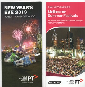
... foldout - with a map showing fire works sites, locations, tram... foldout - with a map showing fire works sites, locations, tram ...Pamphlets - set of 2 printed in full colour on paper folded to DL size. .1 - "New Year's Eve 2013" - 8 fold, 2 half foldout - with a map showing fire works sites, locations, tram alterations, and how public transport could be used in the city. .2 - "Tram service during Melbourne Summer Festivals" - 4 fold, - issued 1/2016, detailing timetable alternations and service changes for Feb. and March - includes events - St Kilda Festival, White Night, Glenferrie Road Festival, Sydney Road festival and Moomba Parade. Has a calendar and maps. Also lists other major events and network upgrade and tram improvement works. Issued by Yarra Trams and the PTV.trams, tramways, events, melbourne, moomba, glenferrie rd, sydney rd, st kilda -
Federation University Historical Collection
Document, Zelda Martin, Central Victorian Goldmining towns - Boom Towns or Ghost Towns?, c1996
Zelda Martin was a PhD candidate at the University of Melbourne.[.1] 4th item in light blue display book titled Research Approach/Overview of Chapters/Confirmation of Canditure/Chapters1,2,3&4 of proposed thesis. *Twenty-seven page article on Victorian goldfields towns titled: Central Victorian Goldmining Towns - Boom Towns or Ghost Towns. The article was written during the author's PhD study. It outlines the context methodology, and resources and the chapters of the proposed thesis: (1) Central Victorian Goldmining Towns - The Context (2) Contemporary Views of the Factors Necessary for Town Growth (3) Outward Manifestations of Town Growth (4) The Trappings of Government (5-9) The Main Towns and Their Hinterland. [.2] 5th item in Light Blue display book as above item. *Chapter 1 of proposed thesis titled 'Pick, Shovel and Tin Dish Mining.' Covers in Section A: Central Victoria - Pre 1851: Aborigines in Central Victoria, Squatters, and Government. Section B: The years 1851-1854: The Early Gold Rushes, Government Reaction, Township Surveys, Legislation, Town Development, Local Government and Early Settlement. [.3] 6th item in Light Blue display book as above item. *2A of proposed thesis titled 'Contemporary Views of the Factors Necessary for Town Growth'. Similar information to Chapter 1 plus extra re towns and maps. Sections: Introduction, Context of Place - Geographical Towns Listed, The Context of Time - Pre1851 Aborigines, Governance of Port Phillip, The Squatters, The Villages of Central Victorian Highlands, Conclusion, Condensed Version of Chapter2B. [.4] 7th item in Light Blue display book as above item. *Chapter2B of proposed thesis. Sections: Area of Research, Schools, Banks, Newspapers, Progress Association, Town Development - Sandhurst (Bendigo), Ballarat, Castlemaine,, Maryborough, Ararat and Stawell. [.5] 8th item in Light Blue display book as above item. *Chapter 3 of proposed thesis titled 'Outward Manifestations of Town Growth'. Sections: Introduction, Contemporary Writing, Educationalists, The Bankers, The Townsfolk, Current Theory, General Theories of Urban Development, and Conclusion. [.6] 9th item in Light Blue display book as above item. *Chapter 4 of proposed thesis titled 'Trappings of Government' Sections: Introduction, Early Government Attitudes to Mining and Town Development, Law and Order, Township Surveys, Legislation, Local Government, Transport and Communication, The People and Lobbyists. [.7] 10th item in Light Blue display book as above item. *'The Rise and Fall of Central Victorian Goldmining Towns'. Includes a map showing main Goldfields, a table showing towns and villages at two points in time - 1857 and 1871; a Bibliography of Primary and Secondary Sources. [.8] Resource No1. Black display book titled Local Towns 1 : Alma: *Brief history *Directory *Maps Amphitheatre / Mountain Hut: *Brief History Post Office Directory Ararat: *Brief History *Post Office Directory 1869 - Alphabetical Listing by Occupation *Ararat - Prominent Citizens of 1858 *Langi-Morgala Museum Avoca: *Brief History *Excerpts from 'Avoca The Early Years', Margery and Betty Beavis; pg1 - Beginnings; pg11 - The Midas Touch; pg25 - Local Gold Escorts; pg27 - A Town is Born; pg51- The Administration of Justice; pg53 - The Ways of the Law; pg61 - News of the Day; pg65 - A Time to Play; pg72 - Land Ownership *Post Office Directory (Bailliere's) 1869 *Tourism Map and Information of area *Historic Avoca - A 5.5km Tour *Avoca & the Pyrenees Region - information pamphlet Ballarat: *Early History of Ballarat - Ballarat Historical Society, Publication No.1: origin of the name; Ballaarat - the Beginning; Fabulous Yields from the Ballaarat Goldfield; *Streetscape Lydiard Street. *Hand drawn map showing Leigh River, Old Portland Bay Road, plaque on road to Colac; etc. *Newspaper article re 'The Theatre Royal' ( which stood in the vicinity of the current Owen Williams store) - 'The News'15/04/1998 *Article - 'Ballarat's Mechanics' Institute Lives On' Ballarat Courier, 14/09/1985 *Article - Standing the Test of Time' The News 17/11/1993 re The Mechanics Institute & picture of the Reading Room *'Ballarat a Study of a City, Phyllis Reichl, pub. Nelson, 1968; no.3 place, time and people field studies series *Investigator Vol.33 No.2, 1998 Geelong Historical Society. Article on pg75 describes Ballarat in 1861 *Folded poster - 'Ballarat 100' a history of telegraph communication, pub. Telecom. Beaufort (Fiery Creek): *Brief history *Post Office Directory [.9] Resource No.2 Black Folder Titled Towns cont.No2 Bendigo (Sandhurst): *'Family & Local History at the Bendigo Library - 1851-2001 150 years of gold'. *Bendigo Government Camp in 1853 illustration; key to sketch and names of Government officers stationed there *Excerpts from 'Bendigo and Vicinity' Adolph Haman *The Bendigo Goldfield Registry - pgs 1-7 Introduction *Excerpt: 'Breaking the Grip' *Excerpt: The Most Go-Ahead Place *Excerpts from 'History of Bendigo' - anti license agitation; laying out of town; proposed railway; gold calls and dividends; the Sandhurst Municipality; journalism *Bibliography Blackwood: *Excerpts from 'Aspects of Early Blackwood - The Goldfield, the Landmarks, the Pioneers' Alan J Buckingham and Margaret F Hitchcock, JG Publishing,1980 Buninyong: *A Brief History *Investigator Vol1 No.2 Feb 1966 Geelong Historical Society. Pg3 - Article re gold escort route - Mt Alexander to Adelaide - (see a simple monument on the Western Highway a few miles out of Horsham. Pg 15 - Ballarat Excursion - re the finding of gold. *Three articles published by Buninyong and District Historical Society Inc: (Magpie Exploration; Finding Gold In The Green Hills; Magpie Exploration; Burnt Bridge to Cargarie to Mt Mercer) *Copies of newspaper articles/items *Buninyong Street Directory Carisbrook: *In the Beginning There Was Carisbrook *The History of the Carisbrook Racecourse Carngham / Snake Valley: *Brief History *Directory Castlemaine: *Directory 1865-1866 - Alphabetical and Street *Poster - Castlemaine A Contemporary Guide "The Great Centre" 1866 - A Contemporary Guide to the Fascinating Past *Pamphlet - Castlemaine District Community Hospital *Map - Castlemaine, Maldon & Surrounding Districts *Map and Information - The Dry Diggings Track - a 55kl walk among historic goldfields relics ( Castlemaine Fryerstown Vaughan Mt Franklin Hepburn Daylesford) *Postcard - Former Court House *Directory 1867 - Alphabetical, Trade [.10] Resource No.3 Grey folder Titled Towns 3 Creswick to Maryborough Creswick: *Brief History *Booklet - "Creswick Cemetery Walk" *Booklet - The Buried Rivers of Gold Heritage Trail Creswick *Creswick Historical Museum Information Sheet *Chronological History of Creswick *Alphabetical Directory of the Borough of Creswick *Creswick's Creek Directory 1856 *Historic Creswick Walking Tour *A Brief Account of the Schools of Creswick - Past and Present *100 Years of Railway Travel in Creswick *The Berry Deep Leads *The Spence Home at Jackass Gully in the Creswick State Forest ( William Guthrie Spence - Pioneer) *The New Australian Mine and the 1882 Disaster *Creswick District News, Issue 7, July August 1999 *The Creswick Miners Walk - Information and Map *Maps Chewton: *Brief History *Directory Clunes: *Brief History *Clunes Street Directory Daylesford: *Brief History *Notable Bushfires in Daylesford District Over More Than a Century - "Black Thursday" 1851; 1862; 1899; the Disastrous Hepburn Fire of 1906; 1939; 1944; 1969. *Post Office Directory -Daylesford and Hepburn Dunolly / Inkerman: *Brief History *Directory *Pamphlet - Goldfields Historical Museum *Pamphlet - Historic Dunolly - Victoria's Best Kept Secret *Map of Gold Workings at Dunolly Area - showing where the main gold rushes occurred *Brief History - Inglewood *Directory - Inglewood - Name Occupation, Dwelling Kingower: *Brief History *Directory - Name / Ocupation / Dwelling Linton / Happy Valley / Piggoreet: *Brief History *Directory - Lintons McIvor: *"A History of the Shire and the Township of Heathcote" by J.O. Randell Majorca: *Brief History *Official Post Office Directory 1869 - Name / Occupation/ Address Maldon (Tarrangower): *Brief History Part 1 *Brief History Part 2 *Post Office Directory *List - Alphabetical Order by Names plus Business and Trade (Tarrangower Times Oct/1858) *List - Alphabetical Order by Trade plus Name and Business *Directory - Name / Occupation / Dwelling Maryborough: *Worsley Cottage - built by Arthur Worsley, a contractor in stonework in 1894 [.11] Resource No. 4 Blue Display Book titled Towns 4 Moliagul to Stawell Moliagul: *Brief History *Moligul Legislative Assembly (Voting?) List - Names and Occupations *Moliagul Victorian Post Office Directory 1868 - Name / Ocupation / Address / Comments *"The Welcome Stranger" gold nugget *The Sunday School *The Welcome Stranger Discovery Walk - information and map Moonambel (Mountain Creek) Redbank *Brief History *List of names extracted from advertisments of the Pioneer and Mountain Creek Advertiser 16/02/1861. *Bailliere's Directory 1869 - Alphabetical List of Name / Occupation / Place St Arnaud: *Brief History Sebastapol: *Brief History *Directory 1869 - Alphabetical by Name; plus occupation and address. Browns and Scarsdale: *Brief History *Browns Street Directory - Name and Occupation Smythesdale: *Brief Description *Smythesdale Street Directory -Name and Occupation Stawell (Pleasant Creek) *Brief History *Victorian Official Post Office Directory - Name /Occupation / Dwelling *Chronology - 1841-1920 *Production of gold statistics - 1879 - 1900 *Big Hill *Extracts from "The Golden Years of Stawell". Chapt 1 - Stawell's Coming Out. Capt. 2 - The Gold Rush. Caapt.3 - Cradle of Democracy. Chapt.4 - The Reefs Becomes Stawell. Chapt. 5 - Rushing In. Chapt.6 - The Pioneers. Chapt 7 - The Decade of Optimism. [.12] Resource No. 5: Blue Display Book titled 'Towns Steiglitz to the The Golden Triangle. Steiglitz: Brief History Victorian Post Office Directory 1869 *Map of Steiglitz *List of maps relevant to Steiglitz history *Information 6 tables of data from "Reports of Mining Surveyors Talbot (Back Creek) Brief History Taradale: Post office Directory 1869 - Name/Occupation/Street. Also list in alphabetical order by Occupation Taradale *Chronological Reference to Taradale Mines *Water - The Coliban System of Waterworks *Joseph Brady *The Syphon Tarnagulla (Sandy Creek) *Brief History *Tarnagulla Businessmen Cameos to give depth to advertisments in 'The Tarnagulla Courier' various issues 1864-1871 *Directory - Name/Occupation /Address *List - Name/Business/Trade Wedderburn (Koorong) *Brief History *List - Name/Occupation The Golden Triangle: *The Early Rushes - Wedderburn / Moliagul / Sandy Creek - Tarnagulla / Jones Creek - Waanyarra / Kingower / Dunolly - Goldsborough / Inglweood *Census of 1857 - Population / Occupations *1858-1871 - A Time of Consolidation- Wedderburn / Moliagul / Sandy Creek- Tarnagulla / Arnold *Census 1871 - Population *Information gleaned from the census data - Demographics / Population / Occupations / marital / Birthplace / Religion / Literacy/ Occupation and Housing Cameos *Graphs - Birthplace of settlers /Male-Female Ratio / Married males / Children under 15 as Percentage of Population / Religion *Census 1857 - Statistical data *Maps *Bibliography [.13] Resource No. 6 - Black Display Book Information and Research in Central Victoria including: *Banking - Research from ANZ Bank Archives *Institutions - also includes articles listed from the Ballarat Times Newspaper *Australian mining History Association - A.M.H.A. Bibliography *Australia's Mining History * Bibliography - Land Surveys Victoria - *1853 Administration (Statistics and Other) includes: schools / ministers of religion / police / military / local administration / licences for sale of spirits / distances between various Victorian gold fields. * Victoria Government Gazette (Copy) - N0. 116, 12/12/1854 includes: Gold Felds Commission of Enquiry & No. 85, 15/09/1854 - Addresses presented to the Lieutenant Governor (Sir Charles Hotham) during his tour through the Gold Fields of Victoria,1854. Addresses on behalf of : the people of Bendigo; Members of the Church of England, Bendigo; Members of the Wesleyan Church on the Bendigo Gold Fields; Bendigo Gold District General Hospital; the Bendigo Prospecting Association; Committee of the Bendigo Local Exhibition; Bendigo District Medical Association; Coloured Americans Resident at Bendigo; German Inhabitants of Bendigo; Landowners, Inhabitants, and Miners of Castlemaine; Inhabitants of Forest Creek; Inhabitants of Heathcote and Gold Miners of McIvor; Residents and landholders of the District of Bacchus Marsh; Inhabitants of Kilmore and Vicinity. *Gold Fields Correspondence 1853: letter from Lieutenant Colonel Valiant, (Officer commanding the Troops in Victoria) to the Lieutenant Governor re threatened disturbance at Sandhurst (Bendigo) regarding the Gold License Fee. * Extracts from a book "Victoria" re Gold Fields Commission of Enquiry involving mainly Ballarat and Castlemaine and a chapter titled 'A Tour to the Victorian Gold-Fields' *Lists of central Victorian newspapers - listed by date published 1851to 1874; by first date available to State Library. *A list of cities and towns showing County, population in 1861 &1871, and municipal status. [.14] Resource no.7. Black display book. *Reference: Papers presented to Parliament Victoria - 1859-1860 4 volumes - relevant sections copied. Contains information on Branches of Government. General / Finance / Gold / Gazette / Commission and Warrant / Statistic. *Gold Fields Act. In accordance with the Act the gold fields are divided into six districts - Ballaarat, Castlemaine , Sandhurst, Avoca, Ararat, and Beechworth.. Official staff in each gold district consists of a Resident Warden, Wardens, Wardens' Clerks, Bailiffs, Chinese Protectors, Chinese Interpreters, and Mining Surveyors. *Gold Receiver *Gaols *Police magistrates and Clerks of Petty Sessions, etc. *Field Branch *Immigration and Emigration Overland - Chinese - 1859 *Population on the Goldfields *The Geological Survey - The Government Geologist is assisited by staff from four branches - the office Branch; the Publishing Branch; the Field Branch and the Museum Branch. *Commission to Enquire Into Sludge dated 10/02/1859 (Some sections copied) - Report to the Honorable Chief Commissioner of Public Works, Melbourne re the mode of carrying the sludge from the puddling mills in Sandhurst without interfering with the drainage of the town and the roads in the neighbourhood. [.15] Resource No.8: Camel display book titled Resource No. 8. Aborigines *Lists of book titles - +"Readings in Victorian prehistory" +"The Aborigines of Port Phillip" +Aboriginal languages and clans" +"A History of the Port Phillip District" +"Langi Ghiran 1: Aboriginal Rock...." +"Koorie History: sources for aboriginal studies in the State Library of Victoria", ed. Tom Griffiths, Melb. Friends of the State Library, 1989 +"The Public Lands of Australia Felix"; settlement and land appraisal in Victoria1834-91 with special reference to the Western Plains", J.M.Powell, Melb. Oxford University Press 1970 +*Bibliography of the Victorian Aborigines' from the earliest manuscripts to 31st December 1970, Massoa, Aldo, Melb. Hawthorn Press, 1971 +"Aborigines in Colonial Victoria, 1836-1886", M.F. Christie, Sydney University Press, 1979 +"Urban and Industrial Australia: readings in Human Geography" ed J.M. Powell, Melb. Sorrett Pub. 1974 *Extracts: -Processes of Pioneer Settlement - The Squatting Occupation of Victoria, 1834-60. J.M. Powell -Areal Variations in the Class Structure of the Central-Place Hierarchy. P. Scott - Volume1 and Volume 2: Notes Relating to the Habits of the Natives of Other Parts of Australia and Tasmania. Compiled from various sources for the Government of Victoria by R Brough Smyth. John Curry, O'Neil, Melb. 1st pub. Melb. 1876. p31-45 - Numbers and Distribution of the Aborigines in Victoria -Victorian Aborigines 1835-1901 - A Resource Guide to the Holdings of the Public Record Office, Victoria; published by the Government Information Centre 1984. *History of the Aboriginal Artefacts Displayed in the Daylesford Museum. F. G. Powell (4 page pamphlet) *Letter to Zelda Martin from Peter Lovett, Cultural Officer, Ballarat & District Aboriginal Co- Operative, 05/02/1997 *Map: Ian Clarke Victorian Tribunal Boundary Map - Clans of Central Victoria. *Victorian Rock Art and Mythology - Article about Mount Langhi Ghiran and myths of the Tjapwarong people. *Two Aboriginal myths relating to the Grampians - 'The Monster Emu' / 'The Aquisition of Fire', by the Aborigines in the Grampians Areas *Article titled (chapter 8) Ballarat - information re camping sites in the region. Lake Wendouree / Lake Burrumbeet (includes a myth) / Mt Bunninyong / Lal Lal / Pitfield / Mount Elephant / Mount Egerton / Meredith / Lake Goldsmith / Lake Learmonth / Ercildoune *Notes on the Aborigines of the Wider Ballarat Region plus European names=Aboriginal names. John Morris 26/07/1995 *Role of Aborigines in Town Development in Central Victoria. Mentions Native Police Force est. in Port Phillip 1842 and Central Board for Aborigines est. 1860 *The Grave of King Billy. (Frank Wilson) Pamphlet. *Camping Places in Central and Northern Victoria. Article re Lake Burrumbeet site. *Programme for the Unveiling of Memorial Cairn for Edward Stone Parker 1802-1865. Note portrait not accurate. Accurate portrait is available in the book "A Successful Failure A Trilogy The Aborigines and Early Settlers", Edgar Morrison, Graffiti Publications, 2002. * Large envelope addressed to Mr G Netherway containing newspaper cuttings regarding the life of Edward Stone Parker, the unveiling of the Memorial Cairn as mentioned above, articles titled 'Episodes from Our Early Days' (Edgar Morrison, Yandoit)- The Black's School, A School At Last and The Final years. Also a typed page titled 'Historical Background to E.S.Parker's Career. Includes an interesting tale titled 'When the cat lay doggo' re laying power leads for the unveiling ceremony at the memorial site. [.16] green display folder titled 'Research Aids' *List of references to Commissioners' & W'ardens' Reports (formerly held at La Trobe Library Archives, now at Public Records Office [PRO]). Indicates town referred to / date of report / name of camp if different to town. * Archive information re Anglican Records *Movement around the Goldfields - Miners and Storekeepers - usefulness of newspapers in providing information - areas covered - Castlemaine, Maldon, Ararat, Stawell, Tarnagulla, Dunolly. *Port Phillip /Victoria Directories 1839/1867 - Chronological list of Directories included in this series. *"Notes on the History of Local Government in Victoria" A.W. Greig Melb. University Press 1925 - Photo-copied extract p5-p40. (Source - Deakin University Library) - Introduction by W.Harrison Moore. Section 1 - Development in New South Wales Before Separation. Section 2 - Development in Victoria After Its Separation from New South Wales. Hand written notations: 'roads, markets, and local government 1855 on' ;'opportunity of squatters in parliament' and 'opportunities of matters in parliament p33' * Notes on the Establishment of Surveyor General's Department 1851and Commissioner of Crown Lands and Survey. * Newspaper articles from The Argus, 1849, re the discovery of gold in the Pyrenees region. * Excerpt - a report on schools - A.B.Orlebar, Inspector; re the need for permanent school buildings rather than tents. *Excerpt from - 'Approaches to Urban History', Sean Glynn: The Case for Caution * Except from - 'The Urban Sprinkle', Weston Bate: Country Towns and Australian Regional History *Reference- 'The History of Land Tenure in the Colony of Victoria', John Quick. References the Haines Land Bill, land tenure and Land Leagues. [.17] Light blue envelope folder titled 'Birtchnell's Ballarat, etc. Directory 1862 *Contains various directories for Smythesdale, Buninyong, Clunes, Brown's and Creswick. [.18] Red envelope folder no.2 titled Victorian Gazetteer *Selected pages from 1869 Victorian Gazetteer on A4 paper (with a handwritten note questioning if some pages are from 1868 Victorian Gazetteer as appears to be different sizes - A3 pages.) Information includes locations and descriptions of towns, hotels, banks, communications and populations. (Does not include names, residences and occupations) [.19] Red Envelope folder titled Bailliere's Official Post Office Directory 1868 (or1869 or a mixture of both?) *Preface *Contains a selection of pages of towns highlighted in yellow in the the index *Work on this directory was commenced in 1867. *Information includes: Municipalities - mayors and councilors; lists of towns naming male inhabitants and their occupations. [.20]Yellow manila folder titled Post Grad Seminar Presentation 1996 *Gives some background to Zelda Martin's proposed thesis and why she chose the topic Gold Mining Towns Boom or Bust [.21] A3 display book - No. 1A * A list of 'Relevant Newspapers collected: The Tarrangower Times and Maldon Advertiser (first published 1858) Includes dates 1858-1867. The Mount Alexander Mail. Includes dates 1854-1866 The Tarnagulla Courier. Includes dates from1864-1871 Dunolly and Burnt Creek Express. Includes dates from 1862-1871 * Selection of newspaper pages from The Mount Alexander Mail 1854 to 1856, mostly showing advertisements for businesses and services provided to that community. [.22] A3 display book - No. 1B * Selection of newspaper pages from The Mount Alexander Mail 1857 to 1866, mostly showing advertisements for businesses and services provided to that community. [.23] A3 display book -No. 2 * Selection of newspaper pages from The Tarnagulla Courier 1864 to 1871, mostly showing advertisements for businesses and services provided to that community. [.24] A3 display book - No. 3 *Selection of newspaper pages from The Tarrangower Times (and Maldon and Newstead) Advertiser 1858 to1867, mostly showing advertisements for businesses and services provided to that community. [.25] A3 display book - No.4 * Selection of newspaper pages from The Dunolly and Burnt Creek Express; and The Dunolly and Betbetshire Express 1862 to 1871, mostly showing advertisements for businesses and services provided for that community. [.26] A3 display book - No.5 Includes: * Bryce Ross's Diggings Directory. Includes instructions for using this directory. This directory was used by "all persons having connexion or desiring to communicate with 'working parties, private friends, or Stores at the Diggings." As a directory for each area wwas completed it was published in each month's issue of Bonwick's "Digger's Magazine." Years c1852/1853. This Directory commences first at the head of Forest Creek. Includes a directory for Bendigo and Ballarat. Of interest at the end of the Bendigo and Ballarat directory is a list of the number of storekeepers, butchers, doctors, smiths, eating houses, lemonade sellers and chapels. * The Castlemaine Directory and Book of General Information Comprehending Glass's Model Calendar for the Two Years 1862 and1863. "zelda martin, victorian goldfield towns, bendigo, castlemaine, ballarat, maldon, stawell, ararat, maryborough, creswick, avoca, heathcote, banks, bank of australasia, union bank of australia, government camp, sandhurst, water supply, tarnagulla, talbot, back creek, mountain creek, police court, carisbrook, dunolly, thompson's foundry, charles clacy, anthony trollope, robert cecil, mount alexander, urbanisation, national schools, education, govenrment, industry, railway, transport, settlement, land settlement in central victoria, steiglitz, joseph brady, the new australian mine, berry deep leads, william guthrie spence, creswick state forest, arthur worsley, worsley cottage, the welcome stranger, moliagul, moonambel, redbank, st arnaud, sebastapol, brown's, scarsdale, clunes, chewton, daylesford, bushfires, inkerman, inglewood, kingower, lintons, happy valley, piggoreet, mcivor, majorca, tarrangower, taradale, the coliban system, the syphon, sandy creek, wedderburn, koorong, arnold, jones creek, waanyarra, the golden triangle, census 1857, blackwood, buninyong, durham lead, magpie, carngham, snake valley, alma, amherst, daisy hill, amphitheatre, mountain hut, beaufort, fiery creek, counties, population, gold fields commission of enquiry1854, william westgarth, gold license fee, lieutenant colonel valiant, administration of the victorian gold fields, commission to enquire into sludge 1859, e.s. parker, edward stone parker, edgar morrison, mount franklin protectorate, dja dja wurrung, memorial cairn, franklinford, mt franklin memorial cairn, jajowurrong, dja dja wurung, tjaowarong, wothowurong, assistant protectors, daylesford museum, buluk, rock art - grampians, aboriginal mythology - grampians, aborigines, first nations people, mount franklin, aboriginal artifacts, lake burrumbeet, native police force, central board of aborigines, yandoit, commissioners' reports, wardens' reports, port phillip/victoria directories 1839-1867, local government - victoria 1853/1854, surveyor general's department - 1850's, victorian schools 1850's, a.b.orlebar, haines land bill, william charles haines, wilson gray, land tenure, land leagues, victorian gazetteer, the tarrangower times and maldon advertiser - 1858-1867, the mount alexander mail 1854-1866, the tarnagulla courier 1864, dunolly and burnt creek express 1862-1871, bryce rose's diggings directory, the castlemaine directory 1862-1863 -
 Lara RSL Sub Branch
Book, Dawn of D Day, 1959
This book was issued in 1960 and is an impression of the experience of the men who landed in the light of dawn on D Day. An impression of what it was like to be dropped from the sky at morning or ship to shore from a landing craft under fire.Historical recount of D-Day landings and subsequent battlesHardcover - dark blue Front Back and spine. The spine has the title printed. Inside front and back cover have illustrated maps by Charles Green. Photographs, maps and illustrations.wwii, d day, battle of normandy, air drop, american air drop, canadian troops, french civilians, invasion fleet, paratroopers, juno beach, invasion beaches, dropping zones, utah beach, omaha beach -
Ringwood and District Historical Society
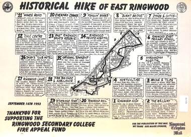
Map, Ringwood Croydon Mail, Map of East Ringwood with numbered sites of interest published by the Ringwood Croydon Mail for Ringwood Secondary College Fire Appeal Fund. 1993, 16-Sep-93
Map of East Ringwood with numbered sites of interest published by the Ringwood Croydon Mail as the major sponsor for Ringwood Secondary College Fire Appeal Fund. The school was extensively burnt in a fire in 1992 which destroyed classrooms, records, musical and sports displays.White sheet of paper with brown printing, A3, with marked locations for visiting. -
 Flagstaff Hill Maritime Museum and Village
Container - Tin Tea Container, Wilson Bros, 1900-1940
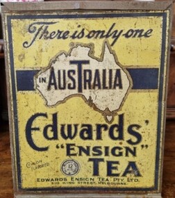
The tin was made by Wilson Bros, Melbourne, for Edwards' Ensign Tea Pty Ltd, Melbourne, Victoria, Australia, 1900-1940. There was a fire at their factory in Flinders Street Melbourne on April 30, 1921 which completely destroyed the building. New premises were obtained at 310/18 King Street Melbourne in 1923. there continued to be bill board advertisements for Ensign tea at the King Street address, also regular adverts in the Argus newspaper during1942.An Australia icon during the first half of the 20th century as tea drinking was a popular past time and social activity.Container for tea with hinged lid. Label yellow with map of Australia. Lid is coming away on one hinge. "Edwards Ensign Tea" On label "Edwards Ensign Tea"flagstaff hill, warrnambool, shipwrecked coast, flagstaff hill maritime museum, maritime museum, shipwreck coast, flagstaff hill maritime village, great ocean road, tea tin, tea caddy, drink, container, wilson bros, ensign tea -
 Bendigo Military Museum
Accessory - BADGES & BUTTONS, c. 1939 - 45
See also 2589 & 2590.1), .2) & .3) Badges, blackened brass, word Australia in a curved shape. .4) & .5) Badges, blackened brass, Rising Sun lapel badges. .6) .7) Badges, pressed metal, gold colour, Kings crown. .8) Button, black plastic, RAAF crown over wings. .9) Button, metal, gold colour, crown over map of Australia wording Australian Artillery. .10) Badge, metal, round Red Cross in white & blue. .11) Badge, metal, gold colour, round section with top clasp. Presented to the children of Victoria for the 1954 Royal Visit. .12) Badge with red ribbon on metal clasp. Badge is oval shaped, Red Cross in centre with white scrolls, Australian Red Cross Society 20 Years Service. .13) Coin, half penny, dented by ammunition fire. .14) Coin, one penny, 1943 dented by ammunition fire.numismatics-badges-military, metalcraft - brassware, costume accessories - clothes accessories -
 Wycheproof & District Historical Society Inc.
Bunguluke Map, Bunguluke District In 1923, 27.2.1923
By 1881 Bunguluke was a small settlement as recorded, December 5, in the Charlton "Mercury". It reports that in that year Draper's Store, Hotel and Post Office and residence at Bunguluke North was totally destroyed by fire. For years now there has been little sign of community life with houses few and far between and acreages have gone into larger holdings. The map references land blocks and owners for that era.This important map shows the local land ownership and local features that existed in 1923. This is a photocopied black and white map of Bunguluke in the County of Kara Kara, Number L5149. Marked - Photo Lithographed by W.J. Butson 27.2.1923. The details include numbers of allotments, property owners, roads, rivers. The boundaries marked are the Parish of Jeruk, Parish of Wycheproof, Parish of Cooroopajerrup. Wycheproof township location is shown with the Scale of Chains. Bunguluke maps for other years are also in the collection.map, bunguluke, jeruk, wycheproof, cooroopajerrup -
 Kiewa Valley Historical Society
Photograph - Bogong Village (7 copies), Approx 1940
In 1940 Field Headquarters for the Kiewa Scheme were established at Bogong with office, workshop facilities and accommodation for workmen, staff and some families constructed. (There had been a 'tent camp' on this site in 1939 but was destroyed by bushfires) Construction of accommodation continued until 1947. A total of 40 houses plus a hostel for single staff, post office, police station, medical centre and primary school all with water and sewerage and electricity supply. The staff hostel was known as Kiewa House and is now occupied by the Education Department. Lake Guy was named after Mr. L.T. Guy who was the Resident Engineer in charge of construction work and associated activities on the Kiewa area. He held this position from 1939 to November 1946 when he was transferred to Head Office. The Bogong Township was developed firstly as an accommodation centre (base camp) for construction workers employed under the Kiewa Hydroelectric Scheme. Due to the influx of European workers into the Township the beautification of the immediate surrounds (gardens etc.) had a distinct European flavour. This environment has been very beneficial for tourism in later years. At the completion of the scheme, in the 1960's, the village was opened to public/tourism use. Strict environmental control has not allowed for any extensive redevelopment in tourist accommodation and basically restricted it to the accommodation initially built for the construction workers. Activities such a bike riding, snow skiing, restricted horse riding and bush walking on the Alpine plains and mountains are now a viable part of the Kiewa Valley Tourist Industry. The lake is one of the many water storage reservoirs used to supply the power stations their main power to run the huge turbines generating the final product, electricity. Evidence can be seen of the 1939 bushfires.Set of 7 identical black and white photographs of Bogong Village after 1939 bush firesHandwritten on the back of one photo - Bogong Village approx. 1940, after 1939 bush fires. Staff residences to left. Kiewa House, General offices and test lab to the right. Hand drawn map on the back of one photo.bogong village, secv -
 Kiewa Valley Historical Society
Leaflet - Kiewa, Welcome to Kiewa
The State Electricity Commission of Victoria constructed the Kiewa Hydro Electric Scheme from 1938 to 1961. The Scheme included three power stations, dams, tunnels and was becoming a popular tourist destination with Falls Creek Ski field within its boundaries.This leaflet was published by the SECV to ensure all visitors to the Kiewa Hydro Electric Scheme were made aware of safety measures with regard to their driving and to bush fires. These were necessary as the area was unique with driving on mountainous roads, changeable and extreme weather and the threat of bush fires. The gatehouse existed during construction, when the SECV was in charge, as a restriction to entry to the Scheme for SECV workers and those with permission to enter. The SECV controlled the area so in case of accident, the SECV was the body to contact not eg. the police.Small white and green leaflet made from one sheet of glossy paper and folded in half. Front cover has the title in the middle, the SECV emblem at the centre top and across the bottom is a message to read the inside pages which are safety messages for driving and bush fires. The back cover has a RACV road map of Kiewa and its 'works' including the Gatehouse which was the entrance to the scheme.The map also has an insert of the main roads & nearby cities. state electricity commission of victoria; kiewa hydro electric scheme; gatehouse; safety rules; kiewa -
 Kiewa Valley Historical Society
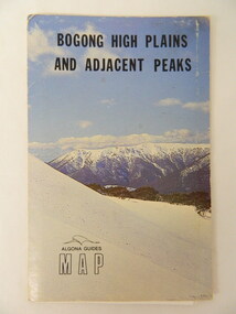
Map - Bogong High Plains & Adjacent Peaks x2, 1976
This map was produced as a result of the 'pressure from walkers' who are interested in climbing the accessible peaks on the Bogong High Plains. Places, huts and rivers are named and indexed. Contours are not given. Heights of mountains are in metres.The Bogong High Plains is a popular walking area and a National Park. This map identifies the mountains and peaks in the area at the time of publication. Some of the huts have since been destroyed by fire and Mt Niggerhead has since been renamed to Jaithmathang.Blue and white cardboard folded in half containing a folded black and white map of Bogong High Plains and Adjacent Peaks with index.bogong high plains. mountains. bushwalkers. walking. map. national park. recreation. cycling. tourism -
 Ringwood and District Historical Society
Document, Historical Hike of East Ringwood -1993
Black and white laminated mapMap includes 20 separate locations of historical interest around East Ringwood. Produced for the Ringwood Secondary College Fire Appeal Fund -September 16th 1993 -
 Eltham District Historical Society Inc
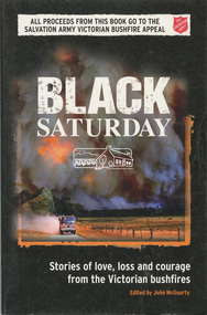
Book, Black Saturday : Stories of love, loss and courage from the Victorian bushfires edited by John McGourty, 2009
The Black Saturday bushfires were a series of bushfires that ignited or were burning across the Australian state of Victoria on and around Saturday, 7 February 2009 and were Australia's all-time worst bushfire disasters. Contributions from reporters and photographers from News Limited. The book is a collection of individual stories, featuring deeply personal contributions from: people directly affected by the bushfires, their friends and relatives; the people who came to their aid - fire fighters, doctors, nurses and wildlife rescuers; accounts from journalists on the scene; and those involved in coordinating the response. Arranged town-by-town, with introductions detailing the scope and impact of the fires on each community. Contents: Kilmore East & Wandong - Strathewen & Kinglake West - St Andrews & Steels Creek - Kinglake - Flowerdale - Marysville--Gippsland -Beechworth & Mudgegonga - the lost ( listing those who perished ) - map of tragedy. Proceeds from the sale of each book was given to the Salvation Army Victorian Bushfire Appeal.SoftcoverYarra Plenty Regional Library identification sticker with name, number and bar code ISBN 9780732290108strathewen, st andrews, black saturday, fires -
 Eltham District Historical Society Inc
Book, Koorie Heritage Trust, Koorie, 1991c
Oldest culture - Yarra River and Port Phillip - Religion - Serpents - Fire - In 1830 - First contacts - Massacre map - Survival - Identity - Resistance and rights (Pastor Sir Douglas Nicholls) - Land rights - From hand-out to hand-back - Aborigines in war - Sportspeople - Cultural heritage.Paperback; 57, [3] pages : illustrations, maps, ports ; 30 cm.ISBN 0724198105aborigines, social customs, koorie, victoria -
 Eltham District Historical Society Inc
Book, Bruce Bence, Kangaroo Ground Bush Fire Brigade, centenary 1892-1992 : the story of the Kangaroo Ground Fire Brigade / Bruce Bence, 1992
Contents (described as Index): The early days, Ewen Hugh Cameron, 1914-1939, Supporting organisations, Eltham Emergency Operations Centre, Kangaroo Ground Fire Brigade Ladies Auxiliary, The fire tower, the Salvation Army and Red Cross, 1930-1992, The Kangaroo Ground Fire Brigade Today, Kangaroo Ground Fire Brigade Chronology. Includes a list of names of office bearers. Also includes references to neighbouring brigades and copies of historical newspaper articles. This publication was supported by the resources, information and facilities of The Shire of Eltham Historical Society.This book is significant in that not only does it traces the development of Kangaroo Ground Bush fire brigade since 1892 and of emergency services in the area but it also gives an insight into the people and their community.Softcover; 61 p., [7] p. of plates : b&w ill., 7 maps, ports.ISBN 064606651Xkangaroo ground, fire brigades, emeregency services, kangaroo ground fire brigade, fires, bush fires, shire of eltham war memorial, kangaroo ground tower -
 Eltham District Historical Society Inc
Book, Country Fire Authority Mapping Association Inc, ESMAP - Outer Melbourne Directory, 1991
Outer Melbourne directory of information for emergencies with maps of the state and major towns217 p. : maps ; 30 cm.ISBN 0646065661emergency services victoria -
 Eltham District Historical Society Inc
Book, School at the crossing place : Lower Plenty Primary School no. 1295, 1874-1974 / W.F. Henderson, 1974c
23 pages including information on inside covers. Text with black and white illustrations and photographs and map. Contents: Crossing Place Need for a school Residence for the teacher Closure A View of Lower Plenty 1918 Moving day at the Village The Golf Club Depression 1931 Vandals Electricity Grass Fires Cows at School Mothers' Club Women's liberation 1950's Lower Plenty after 1945 Swimming Pool - drowned dreams Long Grass - snakes - meadow hay - Fire Brigade The Royal Visit 1954 School Band Community Centre Our School Hall Trees and Gardens The Library Education 1874-1974 A Teacher's View The Second generation - children of ex-pupils (photo with names) The Third generation - Grandchildren of ex-pupils (photo with names) Head Teachers (list with dates) The Staff 1974 (photo with names) The sketch on the cover shows the Lower Plenty Bridge, toll house and the Plenty Bridge hotel, both no longer there. The bridge is listed in the Banyule Heritage Study and has recently been restored by Banyule Council as a pedestrian bridge - NL 137 March 2001 Paperback; [24] p. : ill. ; 25 cm.lower plenty, state school no. 1295, lower plenty primary school -
Clunes Museum
Document - DOCUMENTS/MAP, 1874-5
COLLECTION OF LETTERS - 1 X JANUARY 5,1874 1 X MAY 23, 1874 1 X JANUARY 8, 1874 1 X SEPTEMBER 4, 1874 1 X JANUARY 10, 1874 1 X APRIL 5, 1875 1 X JANUARY 15, 1874 1 X MAY 10, 1875 1 X JANUARY 22, 1874 1 X MAY 13, 1875 (3 PAGES) 1 X JUNE 7, 1875 1 X JANUARY 28, 1874 1 X JUNE 29, 1875 1 X JANUARY 29, 1874 1 X DECEMBER 23, 1875 DONATED TO MUSEUM BY JEFF MACKCOLLECTION OF LETTERS(3) FROM MR. JESSUP (SOLICITOR) OF CLUNES WATER SUPPLY FROM 1870. PRIVATE LETTER FROM JEFF MACKAY. MAP - CLUNES RETICULATION CIRCA 1874. DETAILS OF PIPES LAID AND PROPOSED PIPE LINES, FIRE PLUGS, VALVES.CORRESPONDENCE FROM SOLICITOR (MR. JESSUP) 1874-5document, letters, map, water supply, mr. jessup